Services
LiDAR Laser Surveying
Drone Asset, Building and Roof inspections
Drone Asset, Building and Roof inspections
LiDAR drone surveying involves flying a drone with special payload accurately (RTK precision) over an area generating a 3D point cloud, which can be post-processed afterwards to generate a digital surface model (DSM) or terrain map (DTM). Aerial mapping drone based company based in Bella Vista
Drone Asset, Building and Roof inspections
Drone Asset, Building and Roof inspections
Drone Asset, Building and Roof inspections
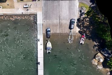
Small size drones are perfect for asset building and inspections of houses and other property. 2D and 3D models can easily be generated through stitching photos with overlaps and automated fly (waypoint) paths.
Beyond Visual Line of Sight - BVLOS
Drone Asset, Building and Roof inspections
Drone Aerial Mapping & Land Surveying
This application involves flying a drone beyond the standard operating conditions (SOC) and multiple trained observers are required with radio communication in place to keep track of the drone one at the time during the mission.
Drone Aerial Mapping & Land Surveying
Drone Aerial Mapping & Land Surveying
Drone Aerial Mapping & Land Surveying
Modern drones are now equipped with RTK capable modules connecting to either base stations or streamed CORSnet service, to acquire real time, accurate positions to allow the capture of high resolution images that can be processed into a 2D/3D model afterwards.
Photogrammetry
Drone Aerial Mapping & Land Surveying
Photogrammetry
Using high quality CMOS sensors on the camera, drones are ideally suited (especially with RTK connectivity or PPK) to capture high resolution images that can be processed into a 2D/3D model afterwards.
Digital Twins
Drone Aerial Mapping & Land Surveying
Photogrammetry
Latest AI technology allows for semi-automatic waypoint missions, capturing the 3D models of buildings, objects and structures quickly and safely without wasting time operating drones manually (traditional methods)
Photo Gallery


This website uses cookies.
We use cookies to analyze website traffic and optimize your website experience. By accepting our use of cookies, your data will be aggregated with all other user data.